It started as a funny game of sorts. As I was scrolling past google satellite imagery dreaming of future canoe country routes and trip plans, I would begin noticing the occasional canoe group on the photos. I soon began looking for them. It was a game of “I spy,” picking out small floating canoes and kayaks within the grand scope of the BWCA. I eventually started taking note of where on the satellite photos I noticed canoe groups. Though the google photos are not taken in a single day, or even in a single year, they still provide an intriguing glimpse into other people’s enjoyment of one of my favorite places. And on a landscape scale, they tell the story of canoe country and the people who flock here every summer in search of adventure, solitude, fishing, challenge, or the serenity that only a wilderness experience can offer. As I spent winter afternoons spotting canoe groups on grainy satellite imagery, it provided a chance to transport myself into their experiences. Some of their stories were presented in the facts of the photos. Others I had to imagine from what I saw and what stories I could conjure from the evidence at hand. And when canoes sat in places I had personally visited, I could simply close my eyes and imagine what those groups must be experiencing. Follow along with me through the collection of grainy images below as we unwrap a birds-eye-view of canoe country.
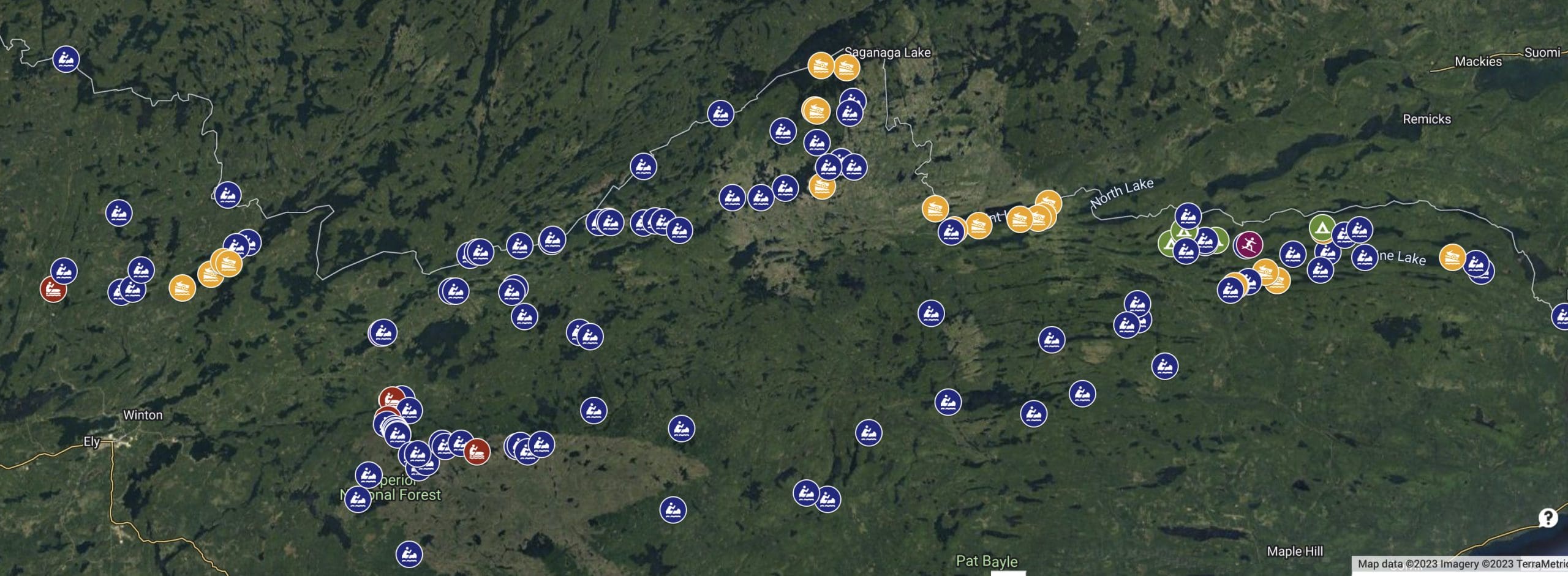
First, all the photos come from google maps. I often use other sat photography, such as the county gis websites, but used google for this one since they are the easiest to map out in their “my maps” software. On the map of all the canoe groups spotted above, you’ll notice some suspicious gaps. First off, I found almost no canoe groups west of Angleworm. Why? Those sat photos seem to have been taken in the off season as one can tell from the sparseness of the forest canopy. In the fall or spring, fewer groups are out paddling and some otherwise busy areas grow quiet. Another example of this is the Gabi/Little Sag/Gillis area which tends to be pretty busy. On this generation of sat photos, they seem almost completely quiet. This confirms that this perspective is not one for judging business in the BWCA or gauging the number of groups on the water at one time. It is an interesting perspective though into individual groups and their experiences, which is what we’ll be diving into.
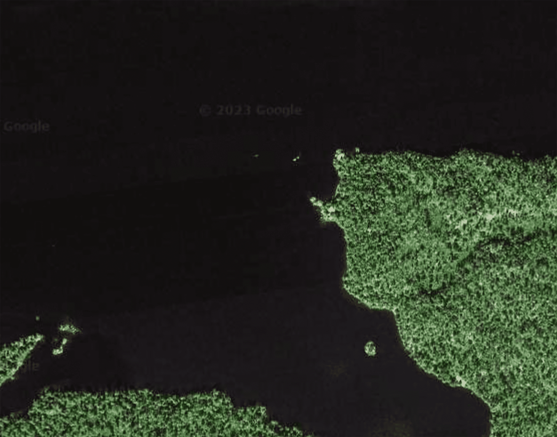
An important note into the process is that spotting canoes on grainy photos of an expansive wilderness can be challenging. Here are two photos, a zoomed in photo of the first, showing a canoe on Alice Lake. Off of the peninsula are two specs, one is a canoe the other is a boulder. This illustrates well how neatly a canoe can blend into a landscape. I think this is a beautiful realization.
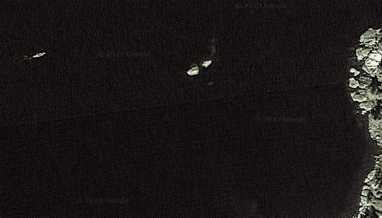
The fact-based parts of a group’s experience are found in the direct evidence in the photo. For example, in the photo below, we can see two paddle blades coming off the hull at the same spot. We also note that it is an open-topped hull (a canoe, not a kayak or a closed-top canoe.) Thereby, we understand that this is a person paddling a solo hull with a kayak paddle.

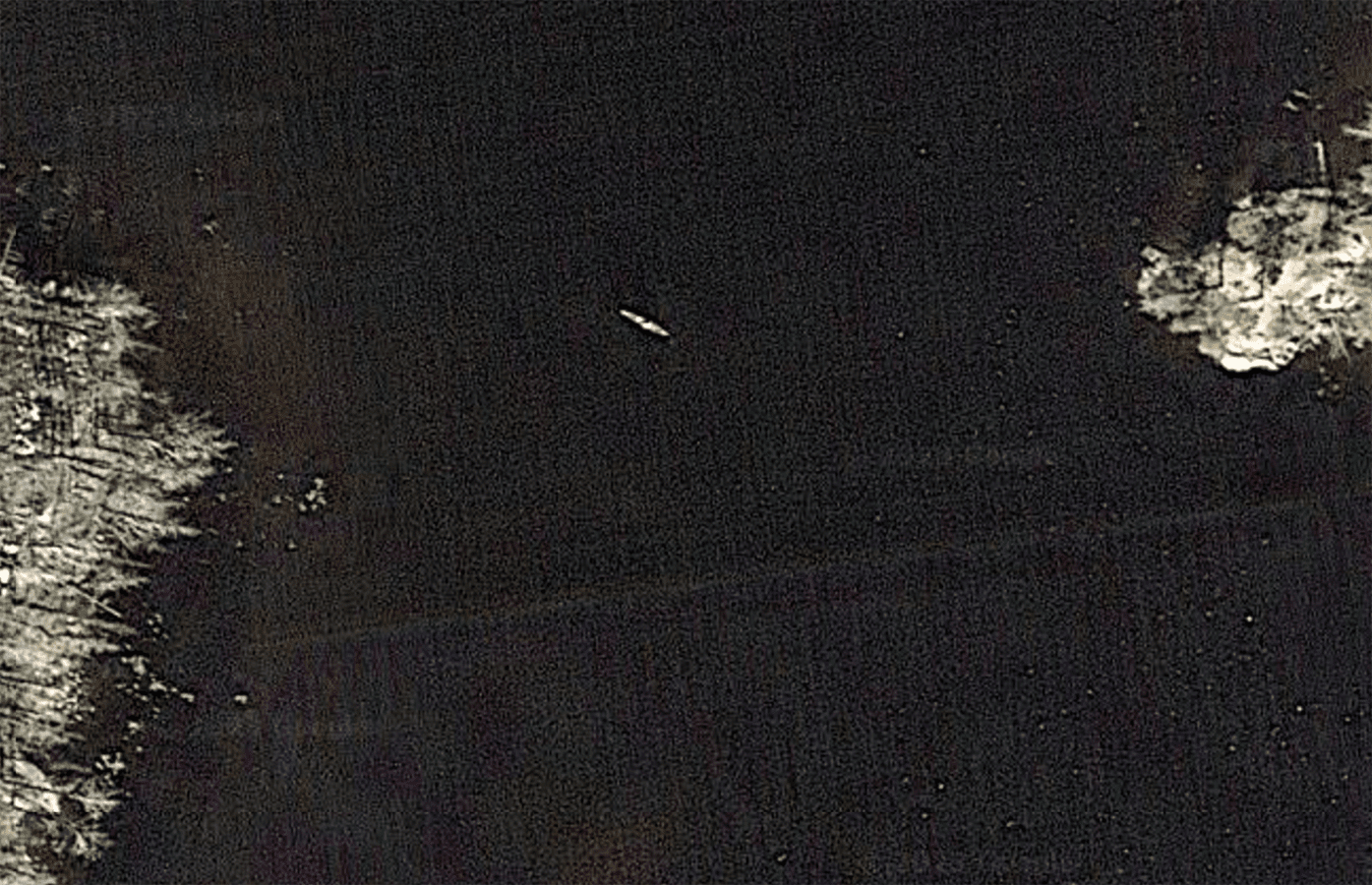
Another fact-based part of these people’s experience is found in the shape of the canoe hulls. A lot can be learned from the general shapes of the hulls and their color. We can learn if the canoe is aluminum or kevlar, if it’s a performance hull or a relaxed touring one, or if it’s being paddled solo, tandem, or in a group of three. Looking at the photo below, we see a very narrow hull, too narrow to be a tandem. This is a performance solo hull and the “bright spots” in the hull confirm that it is only loaded in the middle.
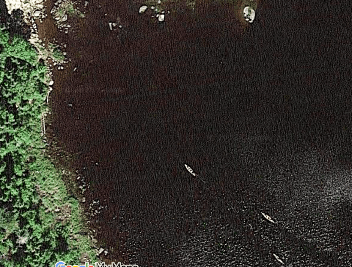
A third fact-based piece of the story we can find in the satellite photos is a group’s direction of travel. Using the wake behind a canoe, we can tell which way a moving canoe is traveling. Generally speaking, a larger wake infers a canoe which is moving faster or is weighted heavier, but, in sat images, tricks can be played by light making some things easier to see on some photos than others. A prime example of all of these things is found in this group of three canoes passing an anchored pontoon on E Bearksin Lake.

After understanding how to interpret the photos, it was fun to begin to imagine the adventures that the different groups were taking. It was also super interesting for me to see each piece of a canoe trip being represented in each different group. It almost seemed like the timeline of an entire trip playing out in the photos in front of me. From the beginning of the trip to the end, on long paddles and tough portages, from campsites to sightseeing and fishing, each and every aspect of a trip was enveloped into the pixels of google sat photos. Step back for a moment and imagine the story of a canoe trip told through these snapshots.
The group sets their canoes in the water to start the trip. After final checks of the vehicles, and the four canoes were loaded, they set off onto the lake. Only a half mile into their adventure, it became clear that there was some discrepancies. Whether it was the paddling proficiency of the lead canoes or the weight in the hulls of the rear, there was lots of space between the four canoes of this group just a short while into their trip. These four are already spread out heading into the Duncan portage on Bearskin Lake. It’s early in the trip yet and there’s plenty of time to figure out the group dynamics.

In the first few hours of the trip close to the entry point, it can be fairly common to encounter other groups. Here on Moose Lake, a canoe group keeps to the side as a pair of towboats head past.

A drive for solitude pushes some groups off the main drag into less-trammeled corners of the wilderness. Spotting this canoe on Grandpa Lake made me smile because I knew the person had very well earned the quiet.

Portaging can be a challenge, especially early in a trip as the kinks are being worked out of the process. Here, a pair of canoes on the far side of a portage in the numbers chain waits to be loaded up with gear. Perhaps the group went back for a second trip or perhaps the canoe carriers went back to help their canoe-mates.

Some portages exist for obvious reasons. Others leave room for rapid-running temptation. Here on the Isabella River, one canoe appears to check out the potential of running the rapids while their other canoe seems to turn in towards the portage.

Especially close the entry point or along busy routes, portages can be pretty easy to spot. Here, a canoe pulls off from a portage onto Ogishkemuncie Lake with the winding portage trail, so deeply carved into the earth from innumerable previous crossings, clearly visible in the burn zone.

Navigating through canoe country is not always easy, and sometimes the person with the map makes unconventional choices. Here’s a group “threading the needle” through a narrow channel between an island and the mainland on the northern arm of Sawbill.

Midway through the day, a group stops for lunch. I have many fond memories of “gunneling up” with group mates, eating lunch, and letting the warm summer breeze drift the canoes ever so slightly. Here’s a pair of canoes side by side doing much the same thing.

Sometimes, a portage really turns into a traffic jam. Here, three different canoes sit on shore and in the water at the landing of the Monument Portage with the first big monument visible to the east.

It’s important mid-trip to take the time to enjoy the view. Here a canoe floats on Eddy Lake with the lake bottom visible as the water deepens heading off-shore.

Late in the day, the group dynamics begin to fray a bit. As the group leaves the portage, they stop for a discussion about how far they’ll head before making camp for the night. The canoe of the group leader with the most BWCA experience surges farther and farther ahead while the other two canoes in the trio begin to tire. Notice the wide space between them in this photo from Insula.

Here’s a group of three canoes sitting across from the Little Caribou campsite facing the site. I know that campsite is a busy one. I can just image the three canoes grouping up to find that one “perfect campsite” they had heard so much about is full for the night. The canoe on the east is already turned to continue onto Pine Lake while the other two are seemingly getting a final glance before moving on.

The day is done and the group finds a place to set up camp for the night. They are planning to head out fishing later so their canoes are left upright and partially in the water as they set up their tent. Here’s a group well set up on their campsite on Duncan.

After setting up camp, some members of the group might head back out to fish or sightsee. Perhaps that’s what’s happening here as a canoe sits in the turbulent water below Wheelbarrow Falls on the Basswood River.

As the group begins to head out of the wilderness, the numbers of groups encountered seems to be going up every mile. Here a group of three canoes on Lake Two pulls into an already occupied portage where a pair of canoes blocks the landing.
It’s a bittersweet feeling the end of a canoe trip. Often, the group is worn and dirty, ready for a hot meal and shower. But the feeling of loss is there too: the loss of the simplistic routines, the quiet, and the rugged beauty. This group is on the home stretch to exit at the [very full] Mudro EP parking lot.

These, of course, represent just a small number of the canoe groups visible on the sat photos of the BWCA, but they give a glimpse into the people enjoying this special place on any given day. Open water season is just around the corner. Hopefully these photos have turned your imagination as they have mine. And the next time you’re panning through your chosen mapping software, keep a lookout for canoes. You might just get a glimpse into another adventure.
And, though I didn’t quite fit it into the storyline, here’s a shoutout to this canoe midway down the Pigeon River. Well done, especially if this was the tail-end of a border route challenge!


Sign up for our newsletter to receive updates about new articles, great deals, and information about the activities you love and the gear that makes them possible:
Have You Read Our Other Content?
")
Let’s Break the Ice on a BWCA November Canoe Trip!
It’s been snowing all week here in Ely which points to a winter season fast approaching. In the meantime, this is one of the more challenging seasons for wilderness travel with many big lakes still open, smaller lakes starting to freeze, and trails and forests covered in fresh, wet snow. To the majority of…

10 Tips and Tricks for Nightime Canoe Travel
The vast majority of BWCA visitors paddle and hike during daylight hours and for good reason. It’s safer, there’s more to see, and daylight travel aligns with normal sleep cycles. Night travel, on the other hand, provides a higher risk of getting lost while paddling; it’s also easier to fall and get hurt while portaging.…
")
Echoes of ’93 – Managing a Complicated Wilderness
“There is currently too much visitor use in some areas of the BWCAW on some days. Excessive use results in the following impacts: Off-site camping on non-designated sites which impacts vegetation, soils, and heritage resources. Some designated campsites and portages are too heavily impacted based upon our LAC inventory data. Approximately 85% of all existing…

Six Rules for BWCAW Portage Etiquette
If you are new to wilderness canoe camping, especially in a heavily used wilderness area like the BWCAW, then the group traffic at some of the busier portages in Canoe Country may come as a shock. Here are six [written and unwritten] rules you should apply the next time you portage on a well-congested portage trail.…

10 Steps in Planning an October Canoe Trip to the BWCA
Fall is a magical season in canoe country: a brief respite of quiet calm between the relative chaos of summer and the icy grip of winter. And, in many ways, the experience of a canoe trip in the BWCA is greatly enriched by the season. Once October 1st rolls around though, the looming threat of…
")
Leave it to Beaver – How Beavers Change the BWCA
When I study nature, I love to learn about the superlatives. I appreciate how the tallest mountains, the biggest trees, or the oldest animals have a way to serve as ambassadors, helping people to appreciate the natural world even if they don’t understand the “nitty-gritty” science of everything. It’s with this mindset that I set…

Worst BWCAW Reviews – The Wilderness is NOT for Everyone
This time of the year, the itch for that perfect summer canoe trip begins to intensify as permits are pulled, routes are planned, gear is cleaned, and the days begin to lengthen! It’s also time to remember that for every person who lives and breathes their wilderness trips, there is another who writes theirs off…

8 Great Places to Canoe/Kayak Camp this Fall in Minnesota
Fall is a magical time of the year to get out and enjoy nature. And for me, I think it’s my favorite season to head out in a canoe to relish in the fleeting days of open water. The Boundary Waters are so special this time of year, and next week’s article will cover how…

The Evolving Food Pack – How Gear Improves Over Time
Every spring as outfitters begin gearing up for the busy summer season ahead, production begins to turn from winter dogsports back to portage packs. Alongside the new gear, a reunion of sorts takes place as old packs come back to us through the fall and into the spring as outfitters send in old gear for…

5 Guide Tricks for Finding Great BWCAW (or Quetico) Campsites
Finding a great campsite can be one of the great joys of a canoe trip. Waking up in a stand of majestic pines, enjoying a cool breeze rolling off the lake on a midsummer afternoon, and cooking over a campfire without worrying about bugs can make a campsite that much more memorable. Occasionally, these sites…
