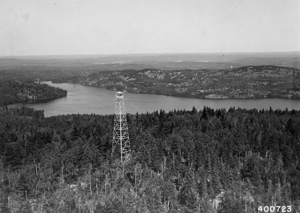
Kekekabic Lookout
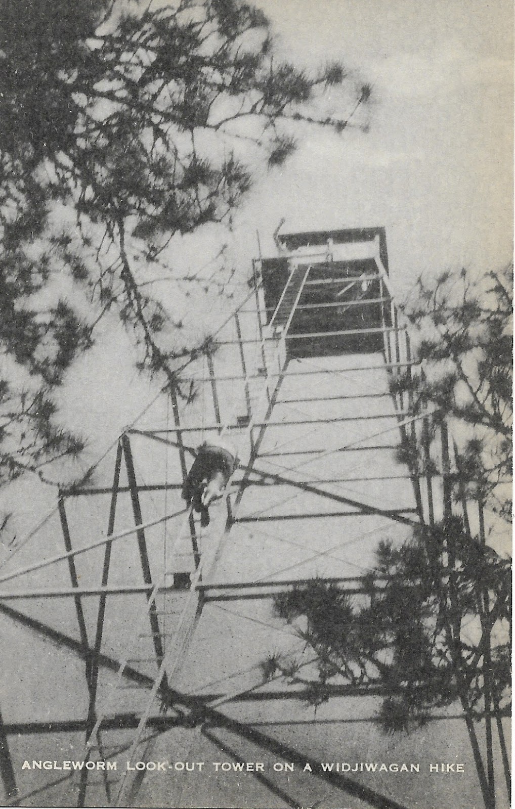
Angleworm Lookout
Slim: Unlike Angleworm or Kekekabic, other towers have very little impact on the average recreationalist, but their history is equally fascinating. When most of us think of fire towers, we imagine these soaring steel structures with a small, enclosed cab on top, and many of our local towers were built this way during the CCC era. These towers were actually just the newest generation in a series of towers with some made of steel and others which stood on timbers. The Slim Tower was a graceful if not rudimentary structure with a small “crows nest” type platform perched atop of a slender steel tower. This old tower was made obsolete by larger towers built during the CCC era and, as such, little remains of it. But, as with most manmade structures, a few remnants may be found such as footings and some cabling. And today as folks drive down Van Vac Rd to enter at Slim Lake or explore the north arm ski trails, they pass by this now-empty hill where rangers once dutifully kept watch.
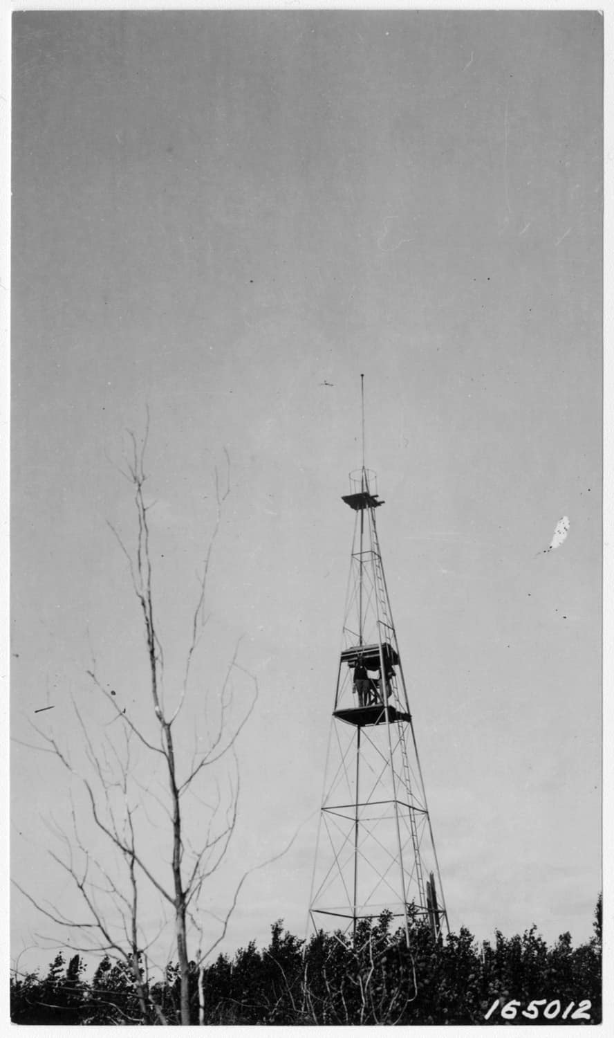
Slim Lake Lookout
In these stories of the old fire towers, though the forest is quickly reclaiming its own, we are reminded that this land has a history. And even if the average canoe tripper or backpacker today is completely unaware of it, the signs and stories of the past are still there for the finding. It’s amazing how much our Boundary Waters experience was shaped by the fire tower and ranger cabin network so that even today, fifty years after the the towers began to close, we are still following the same trails and portages cut by the rangers who used them. This little glimpse of history is, itself, a reminder that in every portage and footpath here we follow in the footsteps of the past. Whether these trails were crossed by voyageurs or native peoples, by legendary figures whose names are familiar to us or people lost to history, in venturing here we share in a piece of their legacy. Think of them on your next canoe trip. You never know what stories lay hidden just around the corner.


Sign up for our newsletter to receive updates about new articles, great deals, and information about the activities you love and the gear that makes them possible:
Have You Read Our Other Content?

The Magic of a Winter Wilderness
The Boundary Waters of northern Minnesota are special. There’s no denying that. Every year, hundreds of thousands flock to this northern wilderness area to experience a landscape where canoes outnumber the cars and a wild landscape is, in some ways, locked in time. But every winter as the canoes are tucked away, the summer tents…

A History of the Humble BWCAW Fire Grate
Across the BWCAW there are campsites big and small. Some have shallow water and sandy beaches, others sit perched high upon rocky outcroppings. Some sit close to shore while others are tucked back into the forest. Some are perfectly suited for a single tent while others could easily accommodate the maximum 9-person group and then…

How to Pack for a Canoe Trip – The Three-Pack System
One of the technical ways flatwater canoe trips are packed differently than backpacking trips is in how to organize gear. In a backpacking trip, the gear in the pack often belongs to the person carrying it, with a few communal items like food or shelter divided between party members. The presence of a bulky watercraft to portage…

Flying South – Where Do the BW’s Birds Go?
Every winter, the forests of canoe country fall silent as so many of the sounds of summer fade with the season. With the coming of winter’s chill, many of the birds that call these wild shores their summer home head south to milder wintering grounds from the rivers of southern Minnesota, the southern states, all…

How to Chase the Northern Lights – A Short Story
Article writing can be a process for me. I usually have five or six partial articles in the queue and sometimes take long breaks from one before coming back to it again. Sometimes there are complicated graphics or illustrations to put together or lots of research to be done. Very rarely is an article reactionary…

The Ten Most Challenging BWCA Lakes to Visit
The Boundary Water Canoe Area Wilderness encompasses over a million acres and 1100 named lakes interconnected by portages and streams, but sometimes that vast expanse can feel a little cramped, especially along entries where larger numbers of groups congregate. For the cynic who feels the BWCA is lacking some inherent quality of wilderness in this…

The Route Planning Game
“Probably the best remedy for the canoe freak is map watching. Pouring over maps can often get you through the canoeless season when nothing else can. I recommend it highly. If you coat the maps with plastic, you can even use them as tablecloths, curtains, and all sorts of things. However, no matter what you…

Six Rules for BWCAW Portage Etiquette
If you are new to wilderness canoe camping, especially in a heavily used wilderness area like the BWCAW, then the group traffic at some of the busier portages in Canoe Country may come as a shock. Here are six [written and unwritten] rules you should apply the next time you portage on a well-congested portage trail.…

2022 Border Challenges
Everywhere one walks and paddles in the BWCA there is a unique connection with the past. Every lake, every portage is filled with stories of legendary figures and lives lived. And through those stories come the marvelous tales of adventure and achievement born of adversity and hardship amidst the beauty. This coming week, a…
")
A Week in January – A Winter Trip Report
The week we had looked forward to had come around again: the Week of Winter annual BWCA trip. This tradition is relatively new, last year was our first, but it seems poised to be a trip that continues annually. January is a fascinating time to take a week long BWCA trip both because winter…
