Upward, upward: Which portage is the tip top?

What is the most difficult portage in the BWCA? This is an impossible question to answer. Is it the steepest? How about the longest? How about the one that has the most mud, the most bugs, the slipperiest rocks, or the worst landing? In truth, the most difficult portage is an entirely subjective question bent to the whims of the context in which you encounter it. An easy portage becomes treacherous in half a foot of snow and a portage that doesn’t challenge a young guide may overwhelm someone who is less physically able or is packed heavier. And just a short journey north to the Quetico or east to the Grand Portage may find larger challenges than can be encountered in the BWCA. But, for this article, I wanted to add one small measure of quantifiable to the otherwise subjective. And so, in the following graph and table, I compared side by side the steepest portages in the BWCA. Even what makes the steepest portage is a measure of some debate. For this article though, I used the total gain in elevation in feet, the number of rods traveled to get there, and the average slope over that distance. Most portages in the BWCA that gain considerable elevation lose some again as they come down to the next lake. In my chart below, I show only the distance utilized to achieve maximum height. The elevation gained may also have some measure of error. I used data from Paddle Planner for this study, and only really fact-checked for the very highest and the very steepest. Besides that, though the USGS data that most maps are based on has its merits, it’s a broad scale. Small yet dramatic changes in elevation are not noted so the handful of portages with true rock faces are not included. Many of the very shortest steep portages are also not included for this same reason. With that out of the way, I will explain some of the most noteworthy results below.
 
Some of the portages on this list are very famous (or infamous depending on your perspective.) Pine to Canoe (Johnson Falls), Stairway, Eddy Falls, and Gijikiki are just some of the names we have all told stories about, but how do they compare? Obviously, the Boundary Waters has zones where the portages are steeper. The area beneath Lac La Croix, the area between the north and south arms of Knife, the Misquah Hills, and the eastern Gunflint all come to mind. The area east of the Gunflint, to no surprise, sees far and away the greatest changes of elevation. Three portages in the BWCA exceed 300 ft of elevation. These all lay east of the Gunflint Trail and include West Pike to Pine, Pine to Long, and McFarland to E Pike. All three of these portages lay within a three-mile circle of each other with West Pike to Pine being the only regularly travelled trail. Pine to Long is a dead-end route with one campsite. McFarland to E Pike is likely not maintained anymore and is slightly overgrown as a result. All three of these portages, though gaining serious elevation, do so at a more prolonged distance. They each take over 150 rods to reach 300 ft of gain, steep for sure, but a shallower slope than others. In addition to three portages that exceed 300 ft of gain, six other portages (five official) gain more than 200 ft. All of these but one also lie east of the Gunflint Trail. Pine to Canoe (just west of the 300s), South to Topper, Mountain to Pemmican, Clearwater to Caribou (eastern portage), Seagull to Paulson, and Clearwater to Rove. Some of these portages are infamous for well-deserved reasons. Seagull to Paulson (a wonderous hike and terrible portage) spends a lot of time climbing up and down over bare rock in its nearly two-mile course. Pine to Canoe sits next to the trail to Johnson Falls. Clearwater to Caribou is a common route to get to Johnson. Others of these may be less well-known. Topper has an infamous reputation for those in the know. Pemmican is stocked with brook trout and so attracts a few brave fishermen. The Clearwater to Rove one may have knowledgeable folks scratching their heads. There is no portage there! To get to Rove you have to go out and around through Mountain…at least today. Once upon a time, there was a marked portage to Rove on old maps. Today, that portage is the spur trail to the Clearwater campsite from the Border Route Trail. I included it for posterity since I have taken it as a canoe portage with a group of high school boys who needed tiring.
 
Next, we have slope. As I mentioned above, I only used the distance from the start of the portage (on its steepest side) to its peak. Most portages climb to a high point and then descend back to the water. I then, using those numbers, took rise over run and then multiplied by 100 to get a percent slope. The results are fascinating. I have long considered Mountain to Pemmican as the steepest portage in the BWCA, and it does deserve that title. From the campsite on Mountain, the portage climbs over fallen logs and through overgrown brush up 236 ft of elevation in 45 rods before coming back down slightly to Pemmican. This equates to an average of 31% slope during the time it spends climbing. Only one portage in my data truly contended with it. Over 90 miles to the west sits Takumich Lake, a deep lake sitting south of Lac La Croix. Out the south end of Takumich is a small lake with the pleasant name of Trillium. This portage, despite being only 40 rods long, gains about 70 ft of elevation in the first 15 rods putting it at about 30% slope also. There are other short portages in the BWCA which come to mind that may also come close, but, again, they are within the margin of error for maps due to their length. Another Takumich portage into Trygg also makes the top 12 steepest slopes. E Bearskin to Moon and Stairway Portage are up there (no surprise, they both have stairs.) Spaulding to Bench and Pine to Vale are both portages to stocked brook trout. As mentioned earlier, the portage to Gijikiki, Eddy Falls, Jasper to Kingfisher, South to Topper, and Hanson to Cherry are well known in their own rights. And, as usual, the rest are less well-known except for those of us who tell stories about them, and that’s the way it should be! These numbers are cool to look at, and the graphic comparing the elevation gained alongside the lift bridge adds perspective. What truly makes a portage though isn’t the numbers but the stories. The hot days with sweat pouring down as you push yourself up the final climb. The early spring trips when the landings are so flooded that you wade ashore. The early summer afternoons when the clouds of bugs fill the lungs every time you try to catch a breath and cover the arms with bites every time you reach to steady the canoe. These are the stories that stick with you that are brought up around campfires or at lunch breaks after you begrudgingly return to work. And it’s the experience of overcoming the elements and the obstacles that give a spirit of accomplishment and adventure more than any number or chart. But for those of us who proclaim themselves geeks of this special wilderness, and seek to understand it at every level we can, this is just one more tool in the belt to appreciate this place at another level.
 
 
Check out the graphics and data below! At least for me, it’s really fun to stare at the names of lakes that I recognize and remember the days I took these portages. Likewise, the remainder of this list allows me to look forward to the challenges that are still to come. The table is color-coded to the lines with the chart to compare portages side-by-side and lists the names of attached lakes in the order they appear on the map. Which of these portages do you remember?

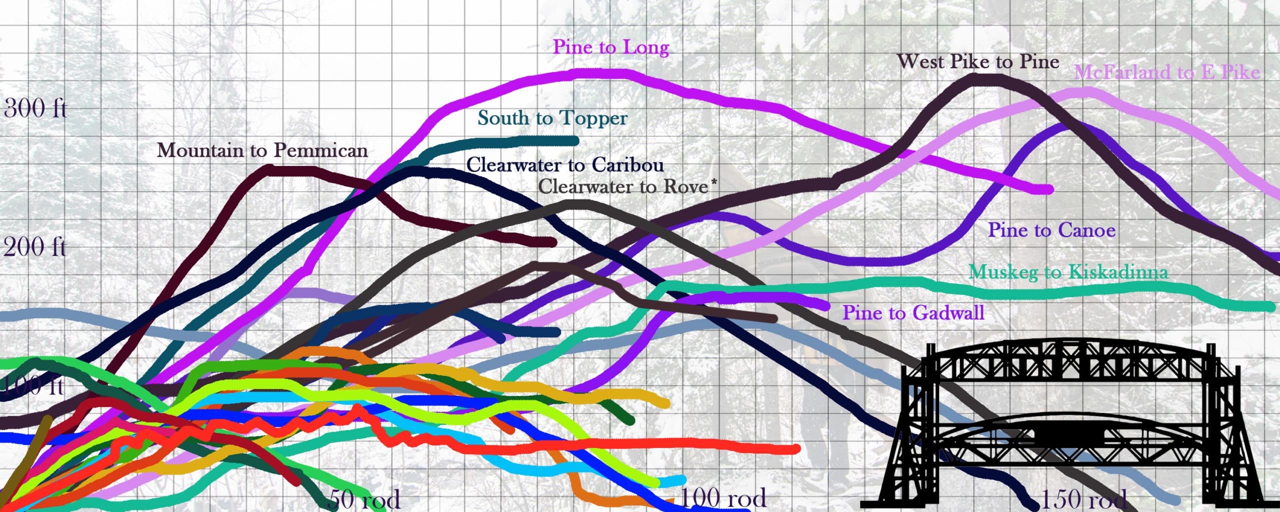
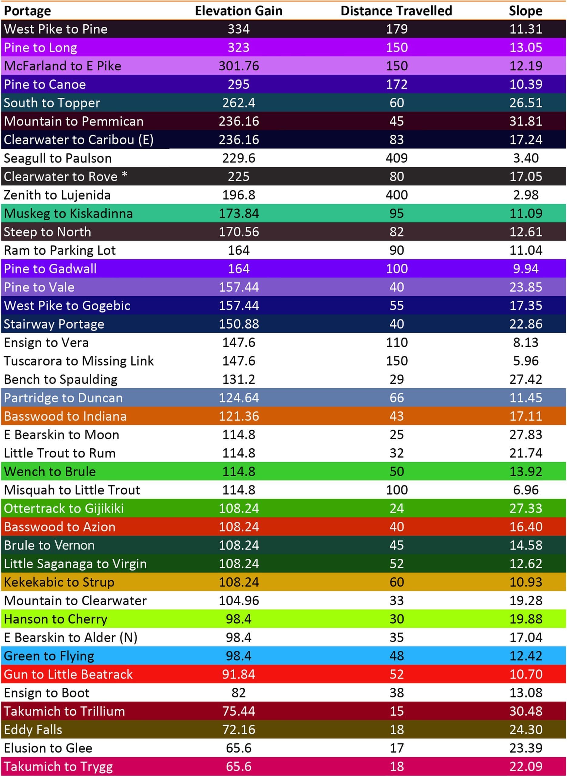
Here the steepest portages in the BWCA are compared alongside the Aerial Lift Bridge in Duluth. The elevations are in feet, the distances are in rods. The lift bridge rods are not correct, it is simply a comparison of elevation.

Sign up for our newsletter to receive updates about new articles, great deals, and information about the activities you love and the gear that makes them possible:


Have You Read Our Other Content?

Map Mondays – Week 3 – Crab Lake/Cummings Lake to Big Lake

By Riley Smith | July 10, 2023

As part of our continuing series on the “route planning game,” we are creating routes using randomly selected entry points, exit points, and number of days to create unique and fun BWCA routes. This week is an arduous 6 night trip through the far western reaches of the BWCA. This area of the BWCA can…

A History of the Humble BWCAW Fire Grate

By Riley Smith | September 29, 2023

Across the BWCAW there are campsites big and small. Some have shallow water and sandy beaches, others sit perched high upon rocky outcroppings. Some sit close to shore while others are tucked back into the forest. Some are perfectly suited for a single tent while others could easily accommodate the maximum 9-person group and then…

The Ten Most Challenging BWCA Lakes to Visit

By Riley Smith | May 16, 2023

The Boundary Water Canoe Area Wilderness encompasses over a million acres and 1100 named lakes interconnected by portages and streams, but sometimes that vast expanse can feel a little cramped, especially along entries where larger numbers of groups congregate. For the cynic who feels the BWCA is lacking some inherent quality of wilderness in this…

10 Steps in Planning an October Canoe Trip to the BWCA

By Riley Smith | October 7, 2022

Fall is a magical season in canoe country: a brief respite of quiet calm between the relative chaos of summer and the icy grip of winter. And, in many ways, the experience of a canoe trip in the BWCA is greatly enriched by the season. Once October 1st rolls around though, the looming threat of…

Leave it to Beaver – How Beavers Change the BWCA

By Riley Smith | August 16, 2022

When I study nature, I love to learn about the superlatives. I appreciate how the tallest mountains, the biggest trees, or the oldest animals have a way to serve as ambassadors, helping people to appreciate the natural world even if they don’t understand the “nitty-gritty” science of everything. It’s with this mindset that I set…

We’re Open – Five Things to Expect In Our New Retail Space

By Riley Smith | June 21, 2022

    If this week’s heat wave has been any indication, summer is here along with all the awesome activities that come with it. It’s time for canoeing, kayaking, fishing, camping, hammocking, hiking, or whatever other activities are going to get you outdoors. If you find yourself heading to Ely for any of these activities…

The Best BWCA Entry Points for Every Winter Activity

By Riley Smith | December 12, 2022

With lake ice quickly becoming travelable, many of us are dreaming about where in the BWCA we’ll head this winter. Winter is a peculiar contrast to summer in this neck of the woods. A whole different gear set is required to travel and stay safe (more on that in future articles.) Accessibility becomes much harder…

Map Mondays – Week 5 – Baker to Magnetic

By Riley Smith | August 7, 2023

As part of our continuing series on the “route planning game,” we are creating routes using randomly selected entry points, exit points, and number of days to create unique and fun BWCA routes. This week highlights a route across some of the busier routes on the eastern BWCA but, in using some creative strategy, allows…

How to Pack for a Canoe Trip – The Three-Pack System

By Riley Smith | May 15, 2024

One of the technical ways flatwater canoe trips are packed differently than backpacking trips is in how to organize gear. In a backpacking trip, the gear in the pack often belongs to the person carrying it, with a few communal items like food or shelter divided between party members. The presence of a bulky watercraft to portage…

Is it Spring in Canoe Country Yet?

By Riley Smith | April 28, 2023

This winter has felt like a long one. The final weeks before opening water always do, but this year has felt extra drawn out. Numerous cities in Minnesota have broken their snowfall records and ice is still firmly on the lakes around Ely. To the Boundary Waters enthusiast, this is a painful time of year…

Author Bio:

Riley Smith

Riley is the Director of Community Engagement and Public Relations for Portage North and Sundog Sport. He comes from a background in wilderness programing and environmental education with four years of BWCA outfitting and guiding before taking this role. In his free time, he can be found out canoeing, hiking, snowshoeing, capturing photography, and writing.
Posted in ,

1 Comments

  1. […] the burden we bear for wilderness travel. Some portages stick with us whether they are steep (see our previous article), filled with obstacles like mud, brush, or boulders, or if they are gathered close together. Other […]

Leave a Reply Cancel Reply